WILDFIRES AND FLOOD DAMAGE
Linking the devastating 2021 fires and floods in British Columbia
A Sparkgeo Story Map by Gordon Logie
Introduction
2021 was a very damaging year for the Canadian province of British Columbia (BC), with the weather exacting a heavy toll. A record-breaking heat wave led into a severe wildfire season. Following these, an extreme winter rainfall event led to catastrophic flood damage which cascaded through the Canadian economy, disrupting major arteries for travel and trade.
Here at Sparkgeo, we are interested in the role that geospatial technology can play to help commercial organizations, municipalities, and the general public adapt to the challenges of a changing climate.
We believe that geospatial technologies can help not only to assess the damage from climate disasters, but also help reveal the underlying geographical factors which contribute to where and why damage occurs. This type of analysis may enable models to predict a particular location's exposure to climate-related risk factors.
To explore this further, we present a research project examining linkages between the wildfires and subsequent flood damage in 2021.
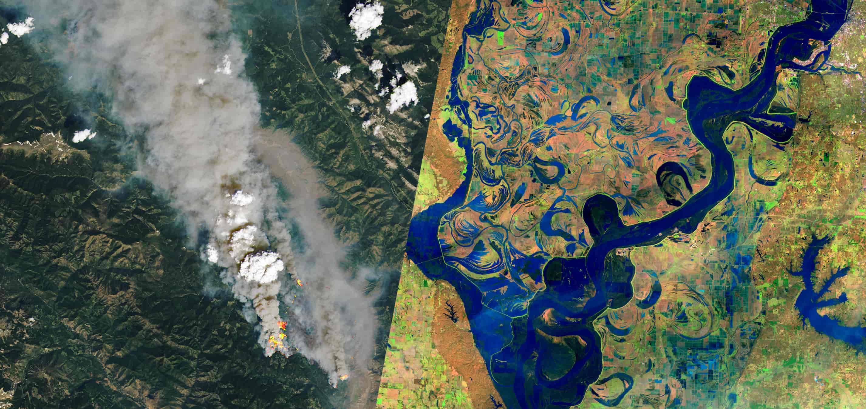
Left: Satellite image shows fires burning in southwest BC in 2021 (image source).
Right: False-color satellite image shows the Mississipi River during intense flooding in 2019 (image source).
Wildfires Enhance Flood Risk
Severe fires can cause a water-repellent crust to form over the soil, reducing the ability for rainfall to infiltrate. This increases runoff during rain events, causing more water to enter streams and rivers and increasing the likelihood of flood damage.
This water repellency can last for several years after a fire, and severe burns can both enhance the effect and make it last longer.
Fire burnt soils are also more prone to erosion from the loss of vegetation cover and changes to the physical characteristics of the soil. More erodible soil increases the risk of landslides and mudslides during severe rainfall events.
Given the above, we wanted to explore how the 2021 BC wildfires and flooding may be linked.
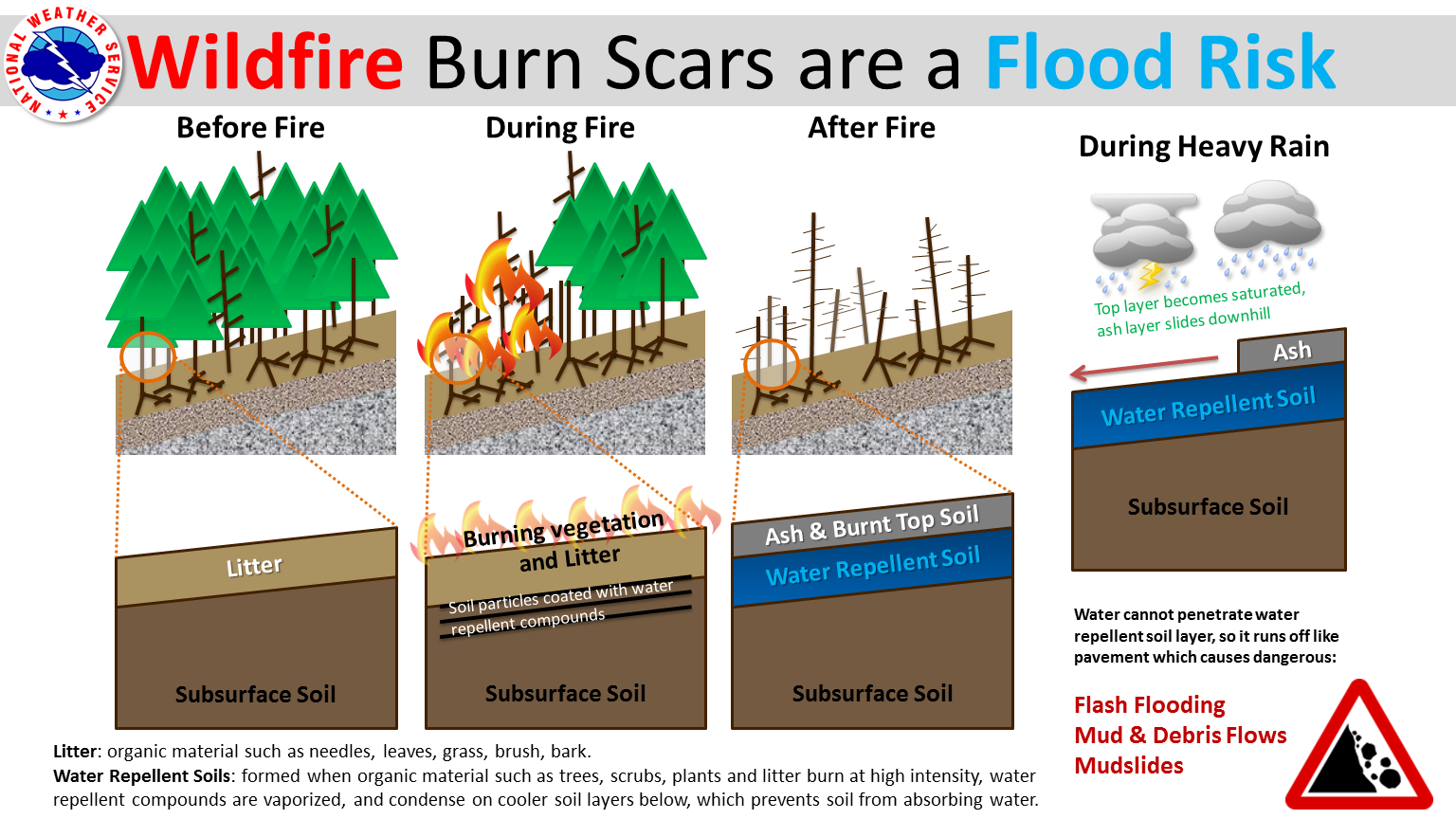
National Weather Service diagram showing how wildfires can enhance flood and landslide risk (image source).
The Heat Dome and Wildfires
In late June an extreme heat wave gripped British Columbia, shattering temperature records in many locations. This event, referred to as the "heat dome", was estimated to cause almost 600 deaths.
Aside from the direct human and economic costs associated with the heat dome, it provided the warm and dry conditions needed to fuel the 3rd worst wildfire season on record.
While only the 3rd worst in terms of area burnt, the 2021 season was notable for the number of large fires that burnt very close to populated areas.
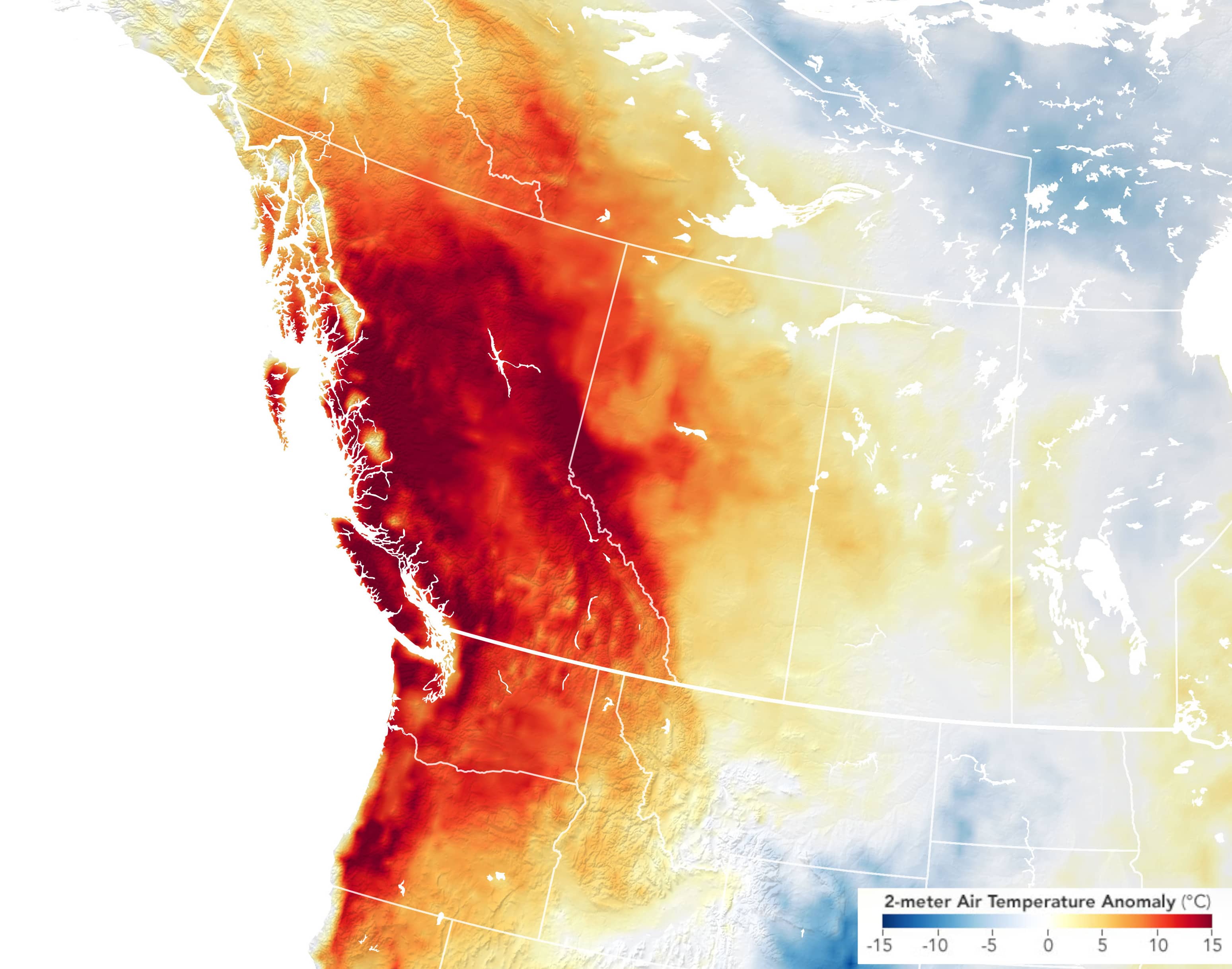
Map showing temperature anomalies on June 27, 2021 in western Canada and the northwestern United States. Temperature anomalies are measured relative to the same-day temperature average during the 2014 to 2020 time period (image source).
Mapping 2021 Fires with Satellite Imagery
We used satellite imagery to map major wildfires in southern BC for the 2021 season. We used multiple sources of imagery in an automated workflow
We mapped fire burn extent and burn severity. Burn severity is important, as some of the strongest and longest-lasting effects following wildfires are associated with severe burns.
For this work we only used the 3 highest fire severity classes: Moderate, Moderate-High, and High severity. This is because the "Low" severity class had a higher false positive rate (classifying unburnt areas as burnt).
For more details on this analysis, please see here.
Shown here outlined in orange are the major southern BC fires mapped for this work. We will explore some of them in more detail below.
Sparks Lake Fire
Size: 89,627 ha
Discovered: June 28, 2021
Cause: Under investigation (human suspected)
The Sparks Lake Fire was the largest wildfire of the 2021 season.
The fire started north-west of the city of Kamloops, and prompted evacuation orders for residents in the Thompson-Nicola Regional District.
While the cause remains under investigation, it is suspected to be human caused.
The fire was finally brought under control in early September after burning an area of over 900 square kilometres.
Continue scrolling to see before and after imagery as well as burn severity data for this fire. Use the "Next Fire" button to skip to the next fires.
Sparks Lake Fire - Before
Image Source: Sentinel-2
Image Date: June 26, 2021
Sparks Lake Fire - After
Image Source: Sentinel-2
Image Date: September 07, 2021
Sparks Lake Fire - Burn Severity
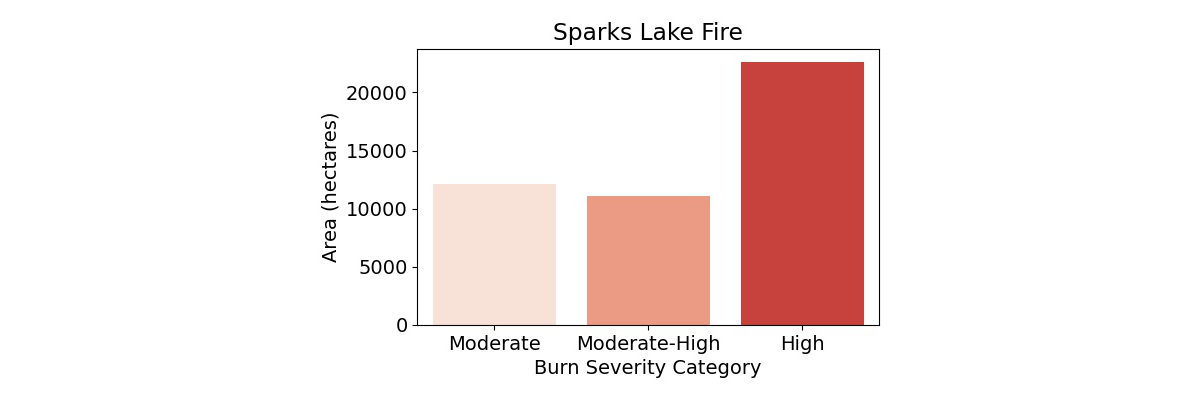
This map shows the burn severity for the Sparks Lake Fire. The chart below summarizes the area in each burn severity class.
Lytton Creek & Mowhokam Creek Fires
Lytton Creek Fire:
Size: 83, 740 ha
Discovered: June 30, 2021
Cause: Under investigation
Mowhokam Creek Fire:
Size: 5098 ha
Discovered: July 9, 2021
Cause: Lightning
The Lytton Creek fire was the 2nd largest and the most infamous fire of the 2021 fire season.
The incredibly warm and dry conditions along with high winds allowed the fire to rapidly advance on the village of Lytton, leaving residents little time to evacuate.
The fire destroyed 90% of the village and tragically caused the deaths of two people.
The Lytton Creek fire was declared under control on September 4, 2021. The cause of the fire remains under investigation but it is believed to have been human-caused.
South of the Lytton Creek fire, the much smaller Mowhokam Creek Fire burned an area around Jackass Mountain, just to the East of the Trans-Canada Highway.
Continue scrolling to see before and after imagery as well as burn severity data for this fire. Use the "Previous Fire" and "Next Fire" buttons to skip between fires.
Lytton Creek & Mowhokam Creek Fires - Before
Image Source: Sentinel-2
Image Date: June 29, 2021
Lytton Creek & Mowhokam Creek Fires - After
Image Source: Sentinel-2
Image Date: September 07, 2021
Lytton Creek & Mowhokam Creek Fires - Burn Severity
This map shows the burn severity for the Lytton Creek and Mowhokam Creek fires. The charts below summarize the area in each burn severity class for each fire.

White Rock Lake Fire
Size: 83, 343 ha
Discovered: July 13, 2021
Cause: Lightning
The White Rock Lake fire was the 3rd largest wildfire of the 2021 season.
It burned on the west side of Okanagan Lake, directly west of the city of Vernon, and prompted evacuation orders for over 900 properties in the central Okanagan region.
The fire burned through the community of Monte Lake, damaging and destroying many properties.
It was finally declared under control on September 03, 2021.
Continue scrolling to see before and after imagery as well as burn severity data for this fire. Use the "Previous Fire" and "Next Fire" buttons to skip between fires.
White Rock Lake Fire - Before
Image Source: Sentinel-2
Image Date: June 26, 2021
White Rock Lake Fire - After
Image Source: Sentinel-2
Image Date: October 04, 2021
White Rock Lake Fire - Burn Severity
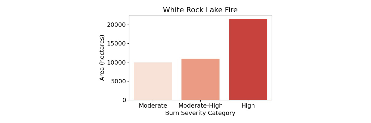
This map shows the burn severity for the White Rock Lake Fire. The chart below summarizes the area in each burn severity class.
July Mountain Fire
Size: 19,080 ha
Discovered: July 13, 2021
Cause: Lightning
The July Mountain fire burnt near the Coquihalla Highway between the towns of Hope and Merritt, one of the busiest transport corridors in BC. Beginning on the west side of the highway, it jumped across to burn on the east side as well. The fire was declared held on September 07, 2021.
Continue scrolling to see before and after imagery as well as burn severity data for this fire. Use the "Previous Fire" and "Next Fire" buttons to skip between fires.
July Mountain Fire - Before
Image Source: Sentinel-2
Image Date: June 29, 2021
July Mountain Fire - After
Image Source: Sentinel-2
Image Date: September 07, 2021
July Mountain Fire - Burn Severity
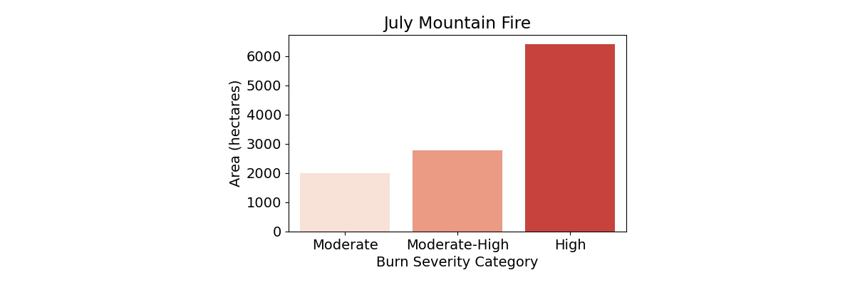
This map shows the burn severity for the July Mountain Fire. The chart below summarizes the area in each burn severity class.
Tremont Creek Fire
Size: 62,524 ha
Discovered: July 12, 2021
Cause: Under investigation
The Tremont Creek fire burned to the south-east of the town of Ashcroft and directly north of the District of Logan Lake, causing an evacuation order for nearby residents.
The fire was declared under control on August 26, 2021.
Continue scrolling to see before and after imagery as well as burn severity data for this fire. Use the "Previous Fire" and "Next Fire" buttons to skip between fires.
Tremont Creek Fire - Before
Image Source: Sentinel-2
Image Date: June 26, 2021
Tremont Creek Fire - After
Image Source: Sentinel-2
Image Date: September 07, 2021
Tremont Creek Fire - Burn Severity
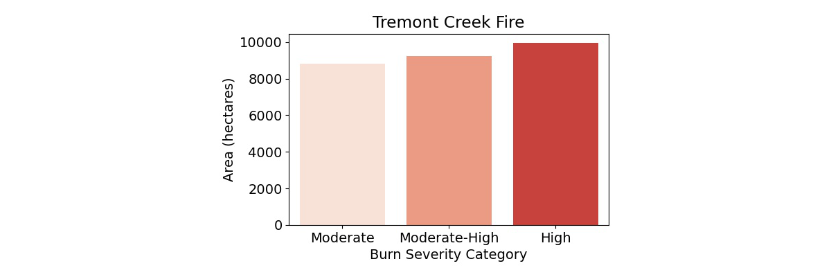
This map shows the burn severity for the Tremont Creek Fire. The chart below summarizes the area in each burn severity class.
Flat Lake Fire
Size: 74,194 ha
Discovered: July 08, 2021
Cause: Lightning
The Flat Lake Fire occurred to the Southwest of 100 Mile House, prompting evacuations in the Cariboo Regional District.
It was declared under control on August 27, 2021.
Continue scrolling to see before and after imagery as well as burn severity data for this fire. Use the "Previous Fire" and "Next Fire" buttons to skip between fires.
Flat Lake Fire - Before
Image Source: Sentinel-2
Image Date: June 29, 2021
Flat Lake Fire - After
Image Source: Sentinel-2
Image Date: September 07, 2021
Flat Lake Fire - Burn Severity
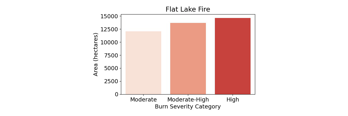
This map shows the burn severity for the Flat Lake Fire. The chart below summarizes the area in each burn severity class.
McKay Creek Fire
Size: 44,964 ha
Discovered: June 29, 2021
Cause: Suspected human caused
The McKay Creek fire burned directly north of the town of Lillooet, causing evacuation orders within the Squamish-Lillooet Regional District.
The fire was declared under control on September 1, 2021.
Continue scrolling to see before and after imagery as well as burn severity data for this fire. Use the "Previous Fire" button to return to the previous fires.
McKay Creek Fire - Before
Image Source: Sentinel-2
Image Date: June 29, 2021
McKay Creek Fire - After
Image Source: Sentinel-2
Image Date: September 07, 2021
McKay Creek Fire - Burn Severity
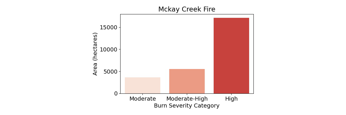
This map shows the burn severity for the McKay Creek Fire. The chart below summarizes the area in each burn severity class.
River Basins and Fires
Two of the largest drainage basins in BC are the Thompson River basin and the Fraser River basin.
The Thompson River is the largest tributary to the Fraser, joining with it at Lytton. From there, the combined waters from both rivers move southwest, discharging into the Strait of Georgia south of Vancouver.
Most of the fires we mapped were within the Thompson River basin. If wildfires produce an enhanced flood risk, we would expect the impacts to be felt primarily in the Thompson basin; however, since the Thompson drains into the Fraser, areas along the Fraser downstream of Lytton may be impacted also.

The Atmospheric River
In mid-November, an atmospheric river brought intense rainfall to south-western BC and northern Washington. Rainfall records were set in 20 communities in BC. In the town of Hope, almost 280 mm of rain fell from November 14 to 15.
This storm caused massive flood damage across much of southern BC. The low lying Sumas Prairie near the city of Abbotsford experienced significant flooding, something we have written about previously. The city of Merritt was evacuated due to flooding from the surging Coldwater River.
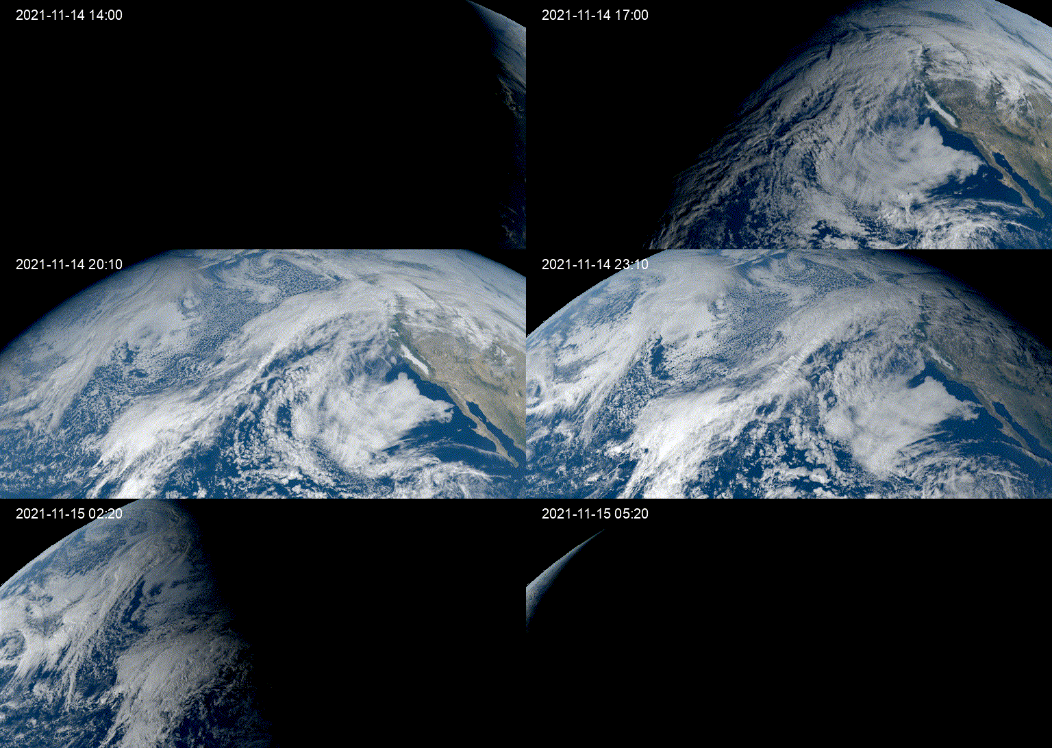
Timelapse of the atmospheric river on November 14, 2021 captured from the GEOS-17 satellite. Animation created using Streamlit for Geospatial.
The Atmospheric River
The storm also caused significant damage to transport infrastructure. Flooding and landslides damaged and destroyed bridges and entire sections of major highways and railways, leading to closures.
Both the Trans-Canada Highway and the Coquihalla Highway were impacted, two of the main arteries connecting the south coast of BC with the rest of Canada. These highway closures led to Vancouver, Canada's 3rd largest city and largest port, being cut off from the rest of the country.
Due to both the cost of repairing the damage as well as the economic impact of supply chain disruptions, the flooding of November 2021 may end up being Canada's costliest natural disaster.
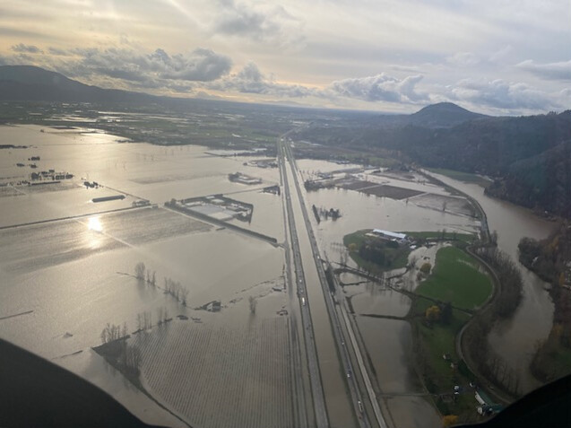
View of the inundated Trans-Canada Highway near Abbotsford (image source).
Total Rainfall - November 11 to 16
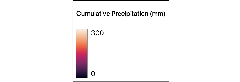
This data layer, derived from the Global Precipitation Measurement Mission (GPM), shows the total rainfall that fell between November 11 through the 16th.
The data is created from satellites measuring microwave radiation, which is calibrated using ground-based weather stations. It is colorized across a range of 0 to 300+ millimeters.
The vast majority of the rain occurred between the 14th and 15th of November. Looking at the data, we see that rainfall from the storm was concentrated around the town of Hope; however, significant rainfall was experienced across much of southwest BC.
Road Damage Locations
We mapped locations of damage along major BC highways, shown here as red dots.
To map the road damage, we relied on the BC Ministry of Transport and Infrastructure Flickr page.
In total we found 36 locations of damage spread across 7 different highways.
The majority of damage we found on three highways: Highway 5 (Coquihalla Highway) between the towns of Hope and Merritt; Highway 8 (Nicola Highway) between Merritt and Spences Bridge; and Highway 1 (Trans-Canada Highway) between Spences Bridge and Lytton.
Burn scars from 2021 fires were nearby to many of the damaged locations along these highways.

Coquihalla Highway
Let us look first at the Coquihalla Highway. The road runs north-east from the town of Hope to the city of Kamloops where it intersects with the Trans-Canada Highway. It is one of three major routes linking Vancouver and the rest of Canada, and experiences the highest traffic of the three.
We mapped 13 locations of damage along the Coquihalla. Most of the damage occurred where the road crossed over or near rivers. Large sections of bridges were destroyed, and portions of the road were washed away. Landslides also covered the road in several locations.
Coquihalla Highway - River Basins
Damage on the Coquihalla was split between the Thompson and Fraser River basins. The divide between the basins occurs at the Coquihalla Summit.
South of the divide, the highway follows the Coquihalla River, which flows in a south-west direction, merging with the Fraser River near Hope.
North of the divide, the highway follows the Coldwater River, which flows north toward the city of Merritt.
We will explore the section of the highway north of the divide first.

Coquihalla Highway - Coquihalla Summit to Merritt
We mapped 5 damage locations along this section of the Coquihalla Highway. We also mapped damage in 2 other locations on secondary roads and bridges near the highway.
In all cases the damage occurred when the road either crossed over the Coldwater River or was nearby to it.
Most of the damage was in close proximity to the burn scar from the July Mountain Fire, which burned on both sides of the highway.
Rain falling on the water repellent fire-scarred soils would have had a higher tendency to run off into the Coldwater river rather than being absorbed. The increased volume of water flowing through the river would have increased its destructive power.
City of Merritt
The surging Coldwater River caused extensive flooding in the city of Merritt, and forced the evacuation of all 7000 of its residents.
Nicola Highway
The Coldwater River joins with the Nicola River at Merritt, and their combined waters flow north-west, joining the Thompson River near the community of Spences Bridge.
BC Highway 8, the Nicola Highway, follows closely to the course of the river and intersects with the Trans-Canada Highway (Highway 1) at the confluence between the Nicola and Thompson rivers.
We mapped damage in 13 locations along Highway 8. Entire sections of the highway were washed away, and several bridges across the river were also destroyed.
Nicola Highway
Most of the damage on Highway 8 occurred where the road passed close to the river, particularly near the outer bank along meanders, curves in the river path where strong bank erosion would be expected.
The scar from the 2021 Lytton Creek Fire was next to the highway for much of its length.
While a lot of the damage could be due to flood waters from the Coldwater River alone, it is possible that rain running off from the fire scar contributed to the road damage, both directly through erosion, as well as by increasing the amount of water in the Nicola River.
Trans-Canada Highway
The Trans-Canada Highway (Highway 1) is a transcontinental highway, connecting all ten provinces in Canada. While this section of the highway is less heavily trafficked than the Coquihalla, east of Kamloops it is the main route through the province.
We mapped 5 road damage locations along the Trans-Canada between the communities of Spences Bridge and Hope.
4 of these occurred between Spences Bridge and Lytton, where the highway follows the Thompson River. The 5th location was south of Lytton, where the road follows the Fraser River.
Trans-Canada Highway
Unlike the damage along the Coquihalla and the Nicola highways, the damage along the Trans-Canada does not appear to be due to heavy river flow; instead, it appears to have been caused by runoff and landslides from the mountain slopes above the highway.
The mountains overlooking the 4 damage locations between Spences Bridge and Lytton were severely afflicted by scarring from the Lytton Creek Fire.
For the single location south of Lytton, the slopes above were scarred from the Mowhokam Creek Fire.
It seems likely that enhanced runoff and erosion from these burn scars contributed to the damage observed on this highway.
Other Road Damage Locations
So far we have looked at highways where recent fires may have contributed to the flood damage.
We did, however, map 11 damage locations which did not directly correspond with any 2021 wildfires.
The majority of these were in the south near the town of Hope. There were also 2 locations further north, near the town of Lillooet.
Road Damage Near Hope
The road damage locations around Hope were all within the Fraser River basin. Most were on the Coquihalla Highway, between Hope and the Coquihalla Summit.
Unlike the north section of the highway, we found no recent fire scars that could have enhanced the damage.
We mapped 6 locations along this section of the Coquihalla. The type of damage included bridge outages along with debris slides from the mountains overlooking the highway.
There were 3 damage locations not on the Coquihalla: one on the Crowsnest Highway (Highway 3) southeast of Hope, and two east of the city of Chilliwack.
High Slopes and Heavy Rains
The area surrounding Hope experienced the heaviest rainfall brought by the atmospheric river.
The large amount of rain in this region was likely enough to cause significant damage regardless of the presence of any recent wildfires.
Another potential factor was the steep mountain slopes in this area. Higher slopes increase the amount of runoff as well as the risk of erosion and landslides.

Road Damage near Lillooet
We mapped two landslides near the town of Lillooet: one was located 30 kilometers to the southeast along Highway 12. The other was 36 kilometers to the southwest along Highway 99 near Duffey Lake.
As with the damage around Hope, we found no recent burn scars which could have contributed to the damage here. The McKay Creek fire occurred just north of Lillooet and likely enhanced runoff entering the Fraser River; however, as the damage at these locations was from landslides, it was not directly tied to damage from surging rivers.
Less Rain than Hope
Taking a look at the precipitation layer, we can see that this region received significantly less rain than the area around Hope.
The amount of rain directly uphill from the slide on Highway 12 (southeast of Lillooet) was around 50 mm according to the precipitation data. While still a large amount of rain, it was not close to the 300+ mm measured around Hope.
The Highway 99 slide experienced higher precipitation around 100 mm; still not at the same level as Hope, but nonetheless a large amount of rain.

BC Highway 12 - Between Lytton and Lillooet
Rock debris covered the highway at this location. The slide coincides with the location of a small stream catchment coming down from the mountain above.
Satellite Imagery
Examining high resolution satellite imagery of the area, there is evidence for previous slides at this location.
This suggests that there may be some other factors which make the slopes here particularly unstable and prone to landslides.
BC Highway 99 - Near Duffey Lake
This slide occurred on Highway 99 near Duffey Lake. Several vehicles were swept away by the slide, tragically leading to five fatalities.
This location is overlooked by steep mountain slopes. As previously discussed, steep terrain increases the risk of landslides.
This coupled with the 100+ mm of rainfall experienced in this area may have been enough to trigger the slide.
Satellite Imagery
Examining the satellite imagery reveals some recently logged clearcuts as well as older clearcuts immediately above the slide location.
While the exact date of this satellite image is unknown, we looked at known imagery from 2021 and the area appeared substantially similar.
There is a relationship between logging and increased landslide activity, so this also may have been a contributing factor.
Adapting to the New Normal
The work presented here is not intended to prove or quantify how recent wildfires enhanced the flood damage in southern BC in 2021. The causes of flood damage are complex and involve the interplay of many different environmental and engineering variables.
A full analysis would require considering more types of data including slope, soil type, proximity to rivers, changes to landcover, and other known factors which contribute to flood damage risk.
Instead, we have tried to show there are some compelling correlations between recent fires and flood damage. Given the evidence presented here and the known relationship between fire and flooding, it seems clear that accurate and timely mapping of wildfire damage is an important part of being able to assess the risk that severe flooding poses to our settlements and critical infrastructure.
The cascade of natural disasters that occurred in BC in 2021 were both tragic and costly. Unfortunately, events like these are predicted to increase in frequency and severity. As predictions continue to become reality, geospatial data and technology will play a key role to help us adapt to this New Normal.
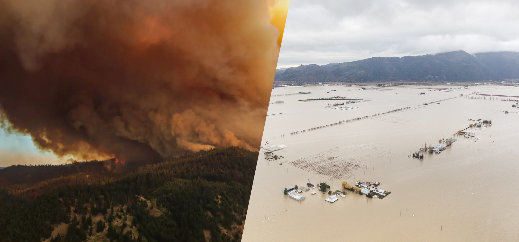
Left: The White Rock Lake wildfire sends clouds of smoke into the sky (image source).
Right: Flooded farmland in the Sumas Prairie near Abbotsford (image source).